
In October, NOAA, the University of New Hampshire Center for Coastal and Ocean Mapping/Joint Hydrographic Center and additional partners from the federal government, academia and the private sector will test the simultaneous, remote operation of two DriX uncrewed surface vessels to map and explore in the Gulf of Maine.
Results of this pilot research and development effort have the potential to increase the scope, efficiency, safety and cost effectiveness of ocean exploration and mapping while also delivering data in previously unmapped areas of the seafloor that are of interest for fisheries, offshore wind-farm development, habitat conservation and more.
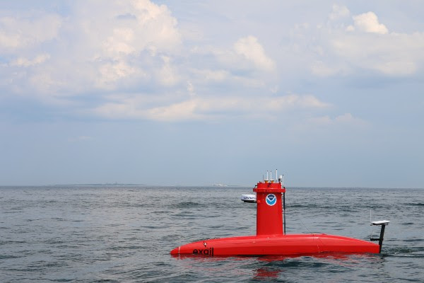
The two DriX uncrewed surface vehicles being used during the month-long mission are autonomous, diesel-powered platforms capable of carrying multiple scientific sensors and conducting a variety of operations following programmed instructions while under constant, remote human supervision. This upcoming mission will mark the first time the team will test the simultaneous operation of multiple uncrewed vehicles from remote, shore-based operation centers.
Previous operations using a single DriX vehicle in conjunction with a NOAA survey vessel resulted in a 20% increase in the ship’s productivity. Adding a second DriX to the mix could increase productivity even further, potentially increasing the area that can be mapped and explored in a given time, enhancing safety of operations, reducing operational costs, reducing environmental impacts, and improving the quality of life for personnel whose ocean surveying careers often require months at sea, all while increasing the volume and quality of data in areas that are important to our nation’s economic livelihood and general wellbeing.
The mission will take place in the Gulf of Maine, approximately 65 nautical miles east of Boston. Each DriX uncrewed surface vehicle is equipped with high-resolution multibeam sonar that can be used to map the seafloor and detect objects in the water column or on the seafloor. The vehicles are capable of operating for upwards of three days at a time before returning to shore for routine checks and refueling.
Co-led by the University of New Hampshire (UNH) and the NOAA Uncrewed Systems Operations Center, with support from the NOAA Ocean Exploration Cooperative Institute, NOAA, the Bureau of Ocean Energy Management, and Exail. This month-long seafloor mapping mission will test the use of two NOAA-owned DriX uncrewed surface vehicles (USVs) operated from a shore-based operations center.
Additional project information and responses to frequently asked questions are available on the project web page. Regular updates will be added to the page throughout the mission.
 Return to the Concord Monitor
I wonder what data they are collecting that the saildrones could not.
https://www.saildrone.com/news/gulf-of-maine-mapping-mission
Good question… The Saildrone and Drix vehicles were/are collecting similar datasets (i.e., high-resolution seafloor mapping and oceanographic profiling) but in completely different regions of the Gulf of Maine.