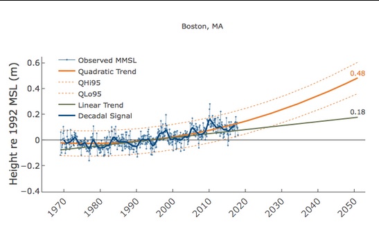
The Virginia Institute for Marine Science has launched a website with a series of “report cards” on sea level rise for 32 dozen U.S. coastal communities. It includes Boston and two Maine cities: Portland and Eastport (which is way up by Canada).
Updated by the Virginia Institute of Marine Science each year as annual tide-gauge data become available, they display recent sea-level trends and project sea-level height to the year 2050 for 32 localities along the U.S. East, Gulf, and West coasts. Our report cards have 3 components: the 2050 projection, recent trends in the rates of sea-level change, and an explanation of processes affecting sea level at each locality.
The Boston chart is shown above. Remember, these are tide levels, not storm-surge levels like that we’ve seen a couple times in the past month.
Ocean-view property is going to get very, um, interesting.


 Return to the Concord Monitor