
In my long journalism career I have never had a chance to combine geometry, historical preservation, vandalism, hiking, map-making, state governance and giant poles atop nail kegs into a single article. Until today.
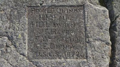
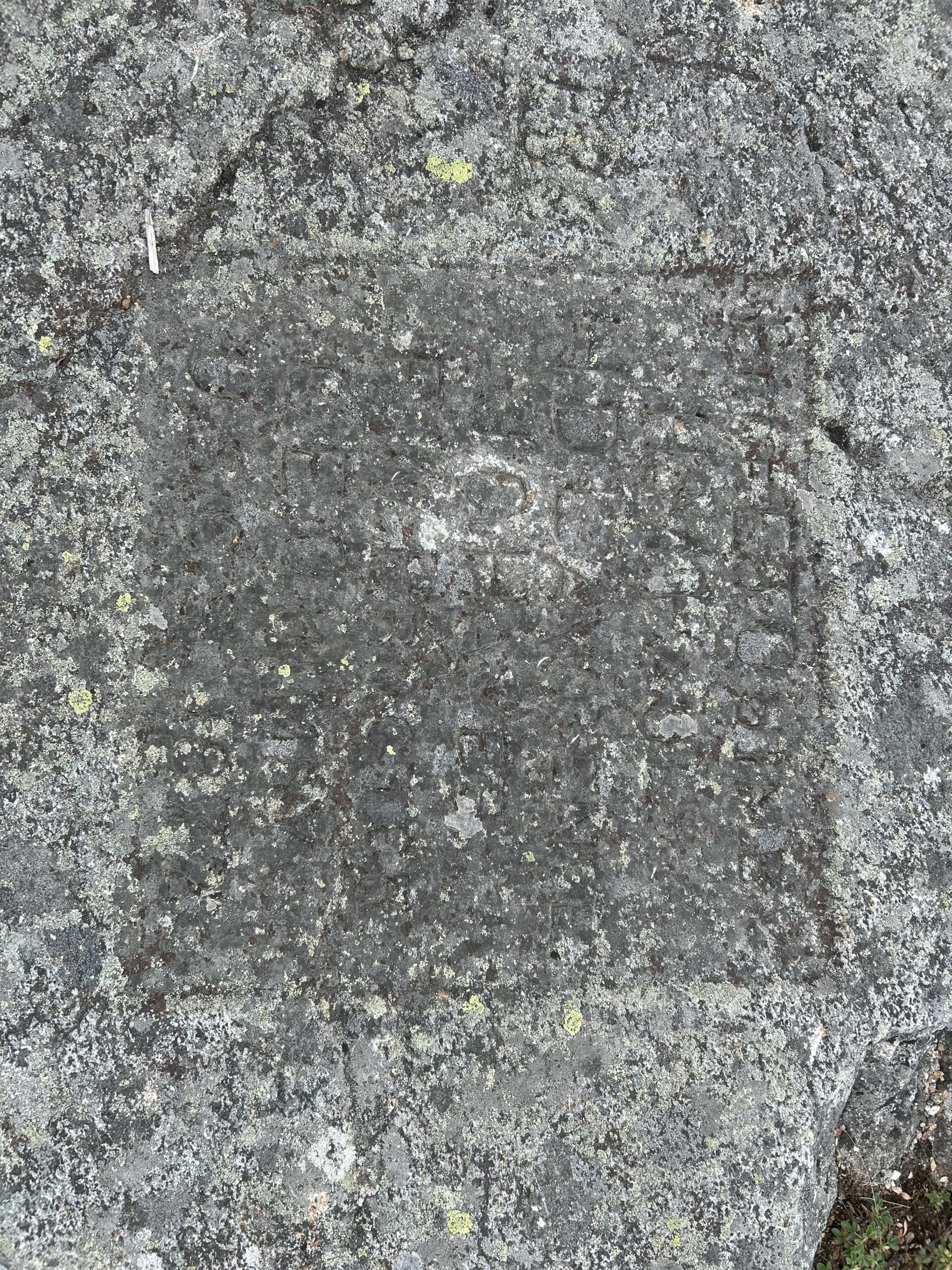
The story’s news hook, as we journalists say, involves what might be the state’s most unusual historical plaque. It was carved into the rock atop Mt. Kearsarge in 1872 to honor work by a Dartmouth professor named E.T. Quimby in creating the first accurate map of New Hampshire by measuring angles from mountaintop to mountaintop.
I have written about the plaque in past years. But there’s a new angle, so to speak.
Quick history: In 1839, New Hampshire Gov. John Page signed “an act to provide for the geological and minerological survey of the state” as part of a national push to make better maps. Quimby, a professor of geography, got the job.
His method depended on triangulation, a system still widely used today. Quimby’s team climbed prominent mountains like Kearsarge or Crotched, crowned them with nail kegs holding a large painted pole to increase visibility, and measured angles between each using a theodolite. Then they took a bit of high school geometry (remember the cleverly named Angle-Side-Angle Theorem?) to create imaginary triangles which eventually covered most of the state and led to the creation of very accurate maps.
The State Archives and Records Management building on South Fruit Street has dozens of Quimby’s notebooks from this multi-year project, filled with penciled notations about angles and distances and locations to everything they could get a bead on, including the State House dome and the spire on my town’s town hall.
As part of all that work, somebody carved the plaque. There’s no record why Mr. Kearsarge was chosen; so far as I know there are no similar carvings elsewhere, although there is a weird cairn near Mt. Sunapee that was placed as part of it.
This brings us to our news hook. A Rhode Island resident named Craig Amerigian contacted me a few weeks ago after he stumbled on the plaque when climbing Kearsarge. The plaque is a little tucked away, not exactly on the summit; even if you’ve been up on what is the highest point in Merrimack County, you may not have noticed it.
Amerigian was curious about it and reached out after finding my previous articles. Time, he said, has not been kind: “You can hardly read it” due to lichen, moss or other growth. “I don’t know if acid rain has accelerated decay of the carving, too.”
He thinks something should be done, although he’s not sure what, which is why he reached out.
I’m not sure either. It seems like it could be cleaned the way old tombstones are regularly cleaned, but you wouldn’t want to accidentally do damage. Any work would need permission — but from whom?
The summit is part of Mount Kearsarge State Forest, while portions of the slope are in Winslow State Park and I’m not sure where the plaque sits in relation to the border. I have contacted New Hampshire Preservation Alliance, which has plenty of experience in saving old things, and the New Hampshire State Parks. I will keep you posted as I learn more.
The complication is that the plaque is, by modern standards, vandalism. We don’t want people carving things into rocks; drawing attention to one such carving might spur copycats.
It’s also not clear how it could be preserved.
“Maybe a bronze frame? Bulletproof glass?” suggested Amerigian with, I think, tongue firmly in cheek.
We could jackhammer all around it and lift it from the rock, giving it to Dartmouth College for their museum. (Yes, I’m kidding.)
Cleaning it and leaving it alone, as is done with carved tombstones, seems the logical course. It would also be nice to add a marker explaining the history.
But that would draw attention and might spur modern rock carvers. Perhaps we should just let it slowly erode back into the stone from whence it came, which after all is the natural progression for all things geological.
As I said, I’ll keep you posted.
 Return to the Concord Monitor
we still carve things into rocks when we do perambulations. usually the year only, but sometimes more. the historic markings include initials of perambulators, often the first letter of each town name, and other markings.
we do not add to the perambulation monument that is, in fact, carved into the rock near the summit of mt kearsarge, part of the warner-wilmot line.
We have plaques and signs all over the place. They don’t seem to inspire more stone carvers or sign makers. All we get from random people is paint graffiti and rock piles.
This guy did great things, the record of his work shouldn’t be left to moulder away. Contact the gravestone preservation folks, they know all about carved rocks.
If nothing else, it might be nice for someone to do a high rez 3d scan of the plaque. Ideally one that “sees through” to the original carving.
Not sure where to put this, so this will have to do…
Every time I leave a comment here I check the “Save my name…” box. But it never remembers me from one visit to the next. In fact, I had checked it when I posted the previous comment, and seconds later, without ever leaving the site, it still didn’t remember my info.
Just sayin’