
At some point 154 years ago, an egregious act of vandalism occurred atop Mt. Kearsarge: Somebody took a chisel and made a 400-square-inch carving in the granite that’s still there today.
Don’t be angry, however. Unlike most graffiti, that carving is unique and historic in a weird sort of way. Plus, I’m happy to report, it’s quite legible.
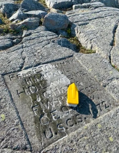
I refer here to an official-looking commemoration of the first accurate statewide map of New Hampshire, a multi-year effort overseen by a Dartmouth professor named Elihu T. Quimby as part of a national program. Nobody knows exactly why this plaque was carved in 1872, or why it’s on Kearsarge rather than more prominent mountains, but it’s a big reason why anybody other than geography nerds remembers the project.
And as I said, it’s quite legible, which came as something of a surprise when I visited it last week following concern from a reader.
Some quick background: I stumbled across this plaque a decade ago after climbing Mt. Kearsarge, which can be reached from either Winslow or Rollins state parks and is one of the nicest day hikes in the region, although the communications tower with its humming generator spoils the wilderness aspect.
The granite ledges on Kearsarge (I think it’s granite, anyway, although it might be schist) have a number of names carved into them dating from the 1800s. Apparently, that was the 19th-century version of marking your tag with spray paint — but this plaque is different, it’s a neatly drawn-up list of six names with a date and the mysterious initials USCS.
Curious, I played reporter and eventually found the story, backed up by a host of documents in the state archives. As it turns out, the federal government paid a bunch of states to make better maps as part of a project by the U.S. Coastal Survey.
Quimby, the professor, got the New Hampshire contract. He and his team spent a few years climbing mountains like Kearsarge that had good visibility all around and took angular measurements from mountain to mountain. Then, they used the mathematical method of triangulation to pinpoint their locations. Triangulation is still the basic method of surveying today; you can read details on the Granite Geek blog in my original 2018 post.
It’s a very cool story from geography and geometry and history points of view. So, I was startled when a reader wrote me earlier this year said the carving was in sad shape, barely legible due to accumulate of grime or lichen or something.
I wrote about this in the Monitor and readers got involved, eventually receiving permission from NOAA, which has jurisdiction over USGS markers, to clean the carving as long as we were gentle.
I went up with soapy water and a few soft brushes to see what I could do only to find that the plaque looks just fine. I used up all the water to scrub off a few bits of lichen — didn’t want to lug that weight back down the hill — but it wasn’t really necessary.
I reconnected with the concerned reader who said his real issue was fear that the plaque is vulnerable to damage and should be protected somehow, although it’s not clear how. I figure that if it has survived 154 years, it is probably OK for the time being.
So, there you have it. If you want to see one of the most unusual historical markers in the state, it’s about 100 yards from the communications tower atop Mt. Kearsarge.
And it’s still just as readable as when Ulysses S. Grant was president.
 Return to the Concord Monitor
There are chemicals used for cleaning gravestones (D/2 is one). They are better than scrubbing for long term preservation of the carvings.
I like to think that somehow Kearsarge was their last stop. They were knackered but also victorious so they took the time to beautifully carve their names before they returned to normal life.