
From UNH Today: A new remotely operated sailboat is soon heading for the high seas for proof-of-concept testing, and scientists are hopeful it will offer a boost in efficiency over current mapping efforts.
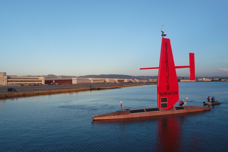
This spring, the Saildrone Surveyor, a 72-foot vessel without a crew onboard, will make its maiden voyage from San Francisco to Hawaii, collecting environmental data and mapping the ocean floor along the way. UNH researchers have been working behind the scenes to make the trip a successful one, most notably by developing software that will ensure the seafloor mapping data is collected with as few glitches as possible and then compressed for satellite transfer to shore.
To date, less than 20% of the global seafloor has been mapped; even on a trip from California’s coastline to Hawaii, it’s surprisingly easy to find areas of the ocean that have not yet been charted, says Larry Mayer, director for the UNH Center for Coastal and Ocean Mapping (CCOM), who has been involved in the project.
The Surveyor is a wind and solar-powered vessel equipped with a suite of sensors and multi-beam echosounders often found on much larger research ships; it’s purported to be much quieter and significantly less reliant on fossil fuels than traditional ocean mapping vessels, making it a more environmentally friendly alternative. The Saildrone company, based out of Alameda, California, designed and built the vessel, with development input provided by researchers from the Monterey Bay Aquarium Research Institute and CCOM.
NOAA’s Office of Ocean Exploration and Research provided funding for the software development and the project’s sea acceptance trials. The NIPPON Foundation-GEBCO Seabed 2030 Project is funding the collection of new seafloor mapping data during the Hawaii transit.
“To me, this project is a match made in heaven,” Mayer says of the collaboration between CCOM and Saildrone. “We’ve been working for years on ways to more efficiently and appropriately process seafloor mapping data as we move into the world of autonomy and thus the collaboration between Saildrone and CCOM makes great sense.”
Kevin Jerram, a CCOM research scientist, and Paul Johnson, a CCOM data manager, have helped to plan for, acquire and process the test data to make sure the Surveyor will accurately map the seafloor once it’s on its way to Hawaii. They coordinated the sea trials for the Surveyor’s mapping systems, a series of calibrations and test surveys that took place off California in late winter to help identify challenges challenges of a new installation on an brand new vessel and make the necessary changes to ensure smooth operations. “The sea trials were important for setting a data quality baseline, ensuring that future missions funded by NOAA and other partners will produce accurate maps as efficiently as possible during the Surveyor’s time at sea,” Jerram explains.
Their involvement with the Surveyor has also benefitted CCOM — Jerram says they gained early experience with the latest mapping hardware and software that is now being installed in other vessels, including the NOAA ship Okeanos Explorer, on which he is currently aboard for similar testing.
“It’s exciting to be involved in this new approach to deepwater mapping, and I truly enjoyed the collaboration with the Saildrone team,” Jerram says. “It feels really good to be getting back to sea, working both remotely and in person.”
If all goes well with the Surveyor’s voyage to Hawaii, Mayer hopes the vessel can be used for the Seabed 2030 mission, an international effort to map the entire global seafloor by the year 2030.
“I’m keen to demonstrate the viability of this sort of approach. If successful, this will represent a quantum leap in our ability to map the global ocean,” Mayer says. “With less fuel usage, no crew costs, the ability to map 24 hours a day, and no need to return to port on a regular basis, we can really increase the efficiency. It makes the aspirational goal of mapping the world’s oceans more hopeful.”
The Institute for the Study of Earth, Oceans, and Space (EOS) is UNH’s largest research enterprise, comprising six center with a focus on interdisciplinary, high-impact research on Earth and climate systems, space science, the marine environment, seafloor mapping, and environmental acoustics. With more than $60 million in external funding secured annually, EOS fosters an intellectual and scientific environment that advances visionary scholarship and leadership in world-class research and graduate education.
 Return to the Concord Monitor