
Last week’s dramatic rescue of a skier who was buried in snow for 6 minutes in Carter Notch was a reminder, if one is needed, that paying attention to avalanche forecasts is vital in the White Mountains backcountry during winter.
But that raises a question: How do they forecast avalanches, anyway? How can you estimate which section of snow on a mountainside is stable and which should be avoided?
Jeff Fongemie starts early.
“I wake up at 4:30, make a cup of tea, sit in front of the computer and look at weather information. Did anything change overnight? That’s one piece of information,” said Fongemie, director of the Mount Washington Avalanche Center.
Recent snowfall, day and night temperatures, winds – those are obvious factors to consider. But a lot of non-obvious (to me, anyway) factors have to be considered as well. Like snowflake shapes.
One task of crews based at Hermit Lake Hut on Mount Washington, a landmark to the hordes of spring skiers heading up to Tuckerman Ravine, is to head out each morning and gather a few falling or recently fallen flakes on a comparison card developed by the International Snow Science Workshop.
“If the observer can see full-size stellar dendrites – classic snowflakes – it tells us that it has fallen out of the sky, not been wind affected. Wind tends to break them into little pieces. That’s going to be light, low-density snow,” he said.
Sounds good, right? Nope. “Stellar dendrites don’t suggest stability.”
The problem, he explained, is that classic snowflakes don’t bond together easily. The bonding of snow, or the lack of it, is at the heart of avalanche forecasting.
“Our avalanche problems tend to be surface problems: new snow sitting on an existing snowpack. Given time, new snow will tend to settle, shrink, and the snow particles bond, becoming less likely to create an avalanche,” Fongemie said. The process takes longer with lighter snow, heightening the danger.
“These are subtle clues, pretty far down the chain for important information. But they’re part of it,” he added.
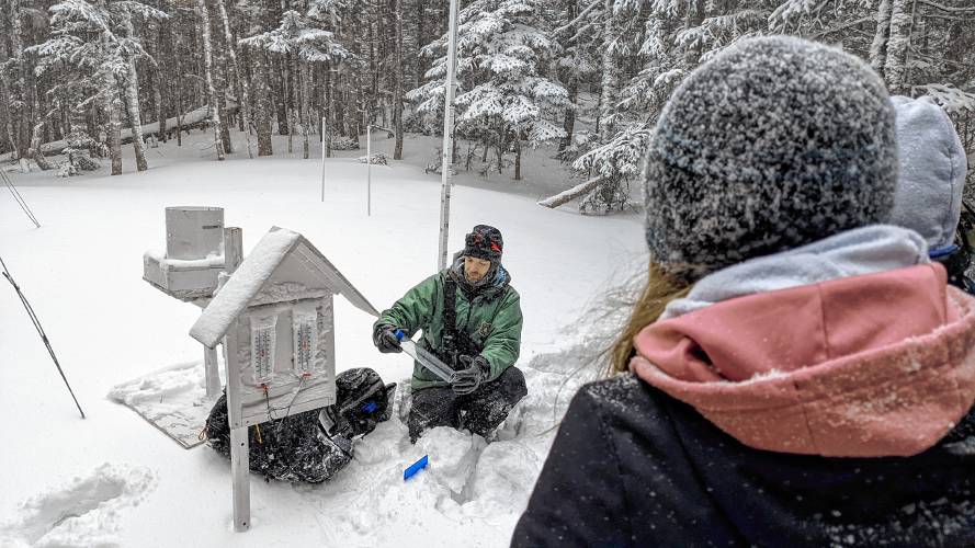
It isn’t easy to determine how well each new snowfall has bonded to those beneath it or how the various layers have changed recently. Joe Roman, backcountry resource manager for the Appalachian Mountain Club, recently created a training video for Hermit’s Lake caretakers, detailing all the techniques they use.
That includes measuring snow temperature daily (with a meat thermometer!) at the surface and at depths of 10 and 20 centimeters as well as maximum and minimum air temperature over the past 24 hours.
“If it was in the 20s all night long, that leads me to think it was promoting stability,” said Fongemie, since 20 degrees is pretty balmy for mid-winter on Mt. Washington. “If it was cold – single digits – it probably didn’t stabilize very much.”
Wind is a factor, too, although it’s complicated. Light winds can destabilize snow but high winds can actually compact it and make it safer.
The type of precipitation also matters. Of particular concern is graupel, which is sort of like sleet and sort of like hail; Fongemie said it acts like “ball bearings,” collecting in pockets and badly undermining subsequent snowfalls.
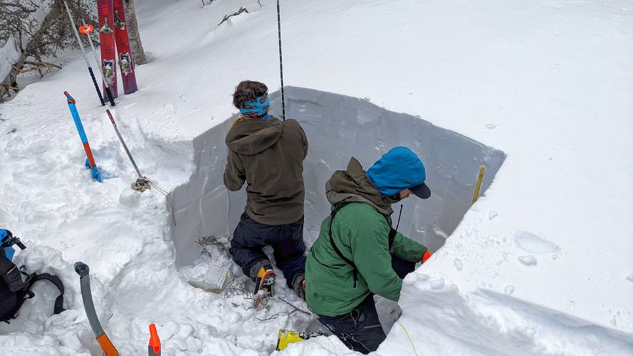
Sometimes teams dig deep snow fits to better see how different layers are interacting.
I am familiar with some of these data-collection methods because, as I have mentioned before, I volunteer for CoCoRaHS, a citizen-science project that gathers daily precipitation data around the continent. (You can do it, too – check the website www.cocorahs.org for details.) Each morning I melt down the snow lying in my yard or that has fallen in the previous 24 hours to get its SWE, snow water equivalent, which is one of the tasks at Hermit Lake Hut.
The SWE tells more than mere snow depth. For example, Monday morning I had 8 inches of snow in my yard, which is average for this time of year, but it melted down to a whopping 2.45 inches of water. My snow is basically 8 inches of ice; if it was fluffy snow it would be 2 feet deep.
This snow weighs a lot more than the depth indicates, which makes it more dangerous if sitting on a steep slope.
Speaking of slopes, avalanches are most likely when the ground is steeper than 30 degrees but less than 45 degrees, so steep that snow doesn’t build up much. The steepest runs in Tuckerman Ravine approach 55 degrees.
In the Whites, location matters a lot.
“It’s variable from one spot to another,” Fongemie said of the risk. In many parts in the mountainous west, “you analyze in one location, there’s a good chance it’s going to be pretty similar in other locations. Around Mount Washington, you analyze snow stability in one spot then walk 10 feet away and it’s totally different.”
This can be seen on the avalanche information sign at Hermit Lake Hut. It doesn’t give ravine-wide forecasts but includes a half-dozen runs in Tuckerman, some of which can carry the ominous notification “undermined snow.”
That brings us to the important point: no amount of forecasting can guarantee safety.
“The answer is always going to be terrain choices. You can’t change the avalanche hazard, can’t change the weather, but if they made better terrain choices they’d be safer,” Fongemie noted. “It’s up to the person in the terrain to decide.”
You can see the Hermit Lake Hut training video on the AMC page on Facebook (it’s not available outside that walled garden, unfortunately): https://www.facebook.com/AppalachianMountainClub/
 Return to the Concord Monitor