
From the Mount Washington Observatory:
The White Mountains are renowned for adventure and extreme weather. Specialized weather information like the Higher Summits Forecast helps search and rescue teams, avalanche experts, and the outdoor community at-large anticipate weather and make safe decisions.
With nearly 800,000 acres of White Mountain National Forest land surrounding the summit of Mount Washington, search and rescue units and scientists performing mountain weather and avalanche forecasting are paramount to the safety of recreationalists and professionals in the region, especially in the winter months. A recent avalanche on Mount Washington that seriously injured a backcountry skier brings to the forefront the importance of forecasting and search and rescue operations.
To take a closer look at the relationship between mountain weather forecasting, avalanche forecasting, and search and rescue in the White Mountains, we spoke with Jeff Fongemie, director and avalanche forecaster at the Mount Washington Avalanche Center (MWAC), part of the U.S. Forest Service with a mission in prevention and search and rescue.
Fongemie has over 30 years of experience in avalanche forecasting, technical rescues, and mountain guiding and has provided avalanche forecast training to many seeking to develop their skills and work toward certification.
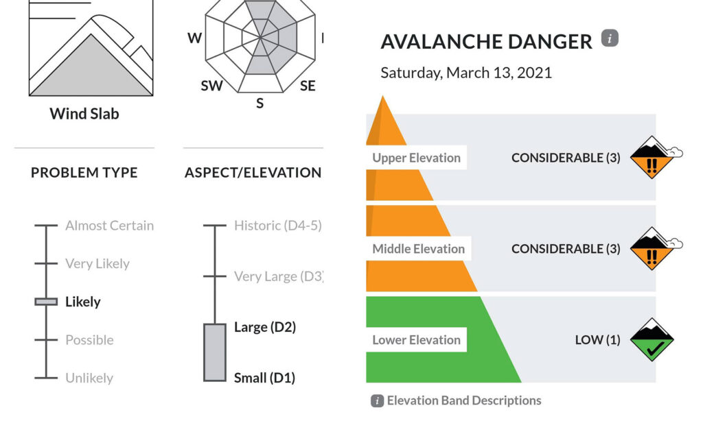
“Elevation-based weather information is critical to the accuracy of our avalanche forecasts,” Fongemie explained. “Our approach involves a detailed analysis of weather patterns and snowpack conditions across different elevation bands within the White Mountain National Forest.”
Specifically, MWAC differentiates between upper elevation (above tree line), middle elevation (tree line to 3000 feet), and lower elevation (below 3000 feet) in their daily forecasts.
Each elevation band can exhibit distinct weather and snowpack characteristics, making this stratification essential. MWAC’s forecast on Dec. 9 when the recent avalanche occurred warned of “isolated areas of unstable snow at middle and upper elevations which could avalanche from the weight of a person.”
Upper elevations are often subject to more severe weather conditions, including much higher winds and lower temperatures, which can lead to the development of different types of avalanche problems as compared with lower elevations.
“By providing elevation-specific forecasts, we enable backcountry users to make more informed decisions based on the conditions they are most likely to encounter in different parts of the forecast area,” he said.
The approach is not just about disseminating information. It’s about enhancing the decision-making process for climbers, skiers, and other outdoor enthusiasts. It’s also about preventing incidents and accidents.
“They can tailor their plans and safety measures to the specific conditions expected at different elevations, thereby significantly reducing their risk exposure,” Fongemie said.
Another integral component of MWAC’s analytics are snow stability tests. Once conducted, they are integrated with Mount Washington Observatory’s (MWOBS) mountain forecasts to assess avalanche risk – a framework that Fongemie noted is a critical aspect of their work at MWAC.
“Snow stability tests are a fundamental part of our fieldwork. This process involves a combination of field observations, scientific analysis, and nuanced understanding of how elevation impacts weather and snowpack conditions,” he said.
The tests involve assessing various layers within the snowpack to understand their strength and the interactions between them. Common tests include compression tests, and extended column tests, among others. By performing these tests at different locations and elevations, Fongemie gains a detailed understanding of the snowpack’s stability across the forecast area.
MWOBS’ Higher Summits Forecast, Current Summit Conditions, and Mount Washington Regional Mesonet provide useful data on temperature, precipitation, wind speed, and direction at different elevations.
“Since weather conditions can vary significantly with elevation, this information is important for understanding how the snowpack might evolve. For instance, higher elevations might experience much stronger winds and lower temperatures, leading to wind-transported snow, which is a critical factor in avalanche formation,” Fongemie said.
y integrating snow stability data with elevation-based weather forecasts, the team at MWAC are able to assess avalanche risk more accurately. This method forms the foundation of their risk assessment process and requires both scientific expertise and practical field experience to provide “accurate, reliable, and timely information to the public.”
If snow stability tests indicate a fragile weak layer at middle elevations and the weather forecast predicts heavy snowfall at these elevations, MWAC can anticipate an increased risk of avalanches in those areas.
“This integrated approach enables us to provide more precise and location-specific avalanche forecasts,” he said.
Fongemie’s team revisits sites regularly to conduct follow-up tests to ensure the most up-to-date evaluation of snowpack stability. This entails an avalanche expert heading out each day on Mount Washington to assess hazards and publish a safety advisory about elevation-based avalanche risk across an area of 106 square miles. They also issue an avalanche-related weather forecast, including details such as snowfall and wind speeds, as charted below.
This ongoing assessment allows their team to adjust forecasts and warnings in response to changing conditions, a process Fongemie describes as “dynamic and continuous,” to enhance the safety of backcountry users.
Elevation-based forecasts are integrated into MWAC’s broader strategy of avalanche risk management by informing not only the public, but also guiding operational decisions.
“This includes targeted data collection efforts and rescue training, which are all adjusted based on the specific risks identified at different elevations on any given day,” Fongemie explained. “This comprehensive and nuanced approach to forecasting is a cornerstone of our commitment to public safety and effective risk management in our internal operations.” A big part of that, too, is education and training, of which MWAC offers many opportunities through partner workshops and in-person educational events.
In winter 2024, a first-of-its-kind immersive internship will combine hands-on training with MWAC in the backcountry and at MWOBS’ summit weather station, allowing university meteorology students to integrate avalanche forecasting and mountain meteorology while applying their knowledge in challenging real-world scenarios.
The Observatory’s Rain-on-Snow research will be a part of the internship experience to assist in snow evaluation and forecasting. This ongoing study takes into account precipitation records over the last few decades and recent occurrences of rainfall on snowpack, an event more commonly associated with the western United States. With a better understanding of the implications that rain on snow layers have on snowpack, a more comprehensive picture of what creates instability in snowpack will help guide future forecasting.
When it comes to search and rescue operations, Fongemie described MWOBS’ forecasts as invaluable – particularly in the challenging and often unpredictable environment of the White Mountains.
He outlined three ways in which the forecasts are applied in search and rescue operations:
- Preparation and Planning: MWOBS forecasts enable search and rescue teams to prepare for the specific conditions they will face. Accurate weather information helps in deciding the timing, equipment, and strategies for rescue operations. For instance, knowledge of an impending storm or severe wind chill can prompt teams to expedite their efforts or to gear up appropriately for extreme conditions.
- Risk Assessment: The forecasts assist in assessing the risks not only for those being rescued but also for the rescuers themselves. In mountainous terrain, where weather conditions can change rapidly, having up-to-date and reliable forecasts is critical for making informed decisions about whether to proceed with a rescue operation or to devise alternative strategies.
- Operational Decision Making: During a rescue operation, real-time weather data from MWOBS Current Summit Conditions and Mesonet can inform crucial decisions. For example, if summit wind speeds increase beyond what was anticipated, rescue teams can adjust their operational strategies on the ground.
 Return to the Concord Monitor