
If you calculate the population center of each state as well as its geographic center, measure the distance between the two and then compare that figure to the total area of the state, you’ll find that New Hampshire has the fourth-biggest relative gap of any state.
Or so says this posting on Maps.com.
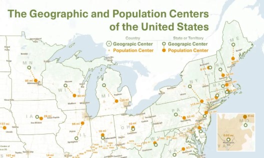
Only Delaware, Rhode Island and Hawaii have bigger relative gaps, showing that small states win this contest because they have a much smaller denominator (total area) when calculating the ratio. The post doesn’t say what the biggest absolute difference is in miles but it looks like it would be Nevada, where the population center is basically Las Vegas, or Alaska, where it’s basically Anchorage.
Calculating the geographic center of Hawaii’s scattered islands must be a bit of a guessing game. But then again, the whole idea of population and geographic centers is far from exact; it requires subjective decisions about time spans, water bodies and other factors. So don’t do anything serous with this data!
 Return to the Concord Monitor
That’s pretty interesting. I worked in Merrimack (which looks to be about the population center) and lived in Alexandria (which looks to be just off the geographic center). Got me a 2fer!
I may be missing something, but: To get the numbers they display, it looks like they take the distance between geographic and population centers (in miles), divide by state area (in square miles), and then (for some reason) multiply by 100. (Because they think it’s a percentage, maybe? It’s not.)
I think they would get different numbers if they used different units.
I assume they multiply by 100 to avoid decimal points, which might complicate spreadsheet analysis. As for different units, presumably if they were consistent the calculation would be the same – meters vs. square meters as compared to miles vs. square miles.
Looking at their bar chart, they do not avoid decimal points.
If they wanted to calculate a unit-independent number, they should have done what those “state ruggedness” calculators did that you posted a few days back: divide by the square root of the state’s area instead. (Throw in a factor of pi if you want to assume a circular state instead of a square one.)
I think that would remove a lot of the small-state bias you noted.
But I think I’m probably taking this too seriously. I’ll stop now.
When I first moved to Alaska in the late 1970s, the biggest problem wasn’t the distance between the capital city and the biggest population center, it was the fact that the two were separated by two time zones! I worked for the Alaska Marine Highway in Seward, and if we needed something from Headquarters in Juneau after 3 p.m., too bad for us: it was already 5 p.m. in Juneau, and everyone from HQ had already gone home. Every year, a group of business leaders and politicians in Anchorage would try to get the capital moved from Juneau to Anchorage (which contained about 1/3 of the state’s population), much to the horror of the rest of Alaska, as everyone outside of Anchorage was afraid that that would create too much concentration of power, money and political attention. Finally (and after I’d already moved to a city in Southeast Alaska, in the same time zone as Juneau), the Alaska legislature passed a law to give Alaska one time zone, across vast distances, with an exception made for the furthest western islands in the Aleutian Chain, more or less taking the efforts to change Alaska’s capital city off the table.
Remember the Alaska capital for a while was going to be Willow? Because it was a neutral
place and sort of between Anchorage and Fairbanks. So closer to both the population and geographic centers. Nevermind that it was also the storehouse of the snows. Remember the fanciful drawings of the capital that would need to be built entirely from scratch?
That example aside, I can’t see the value of these dubious statistics.