
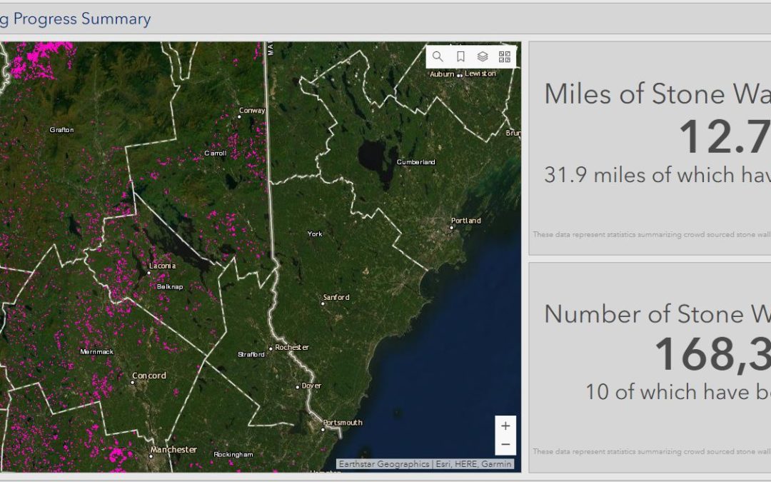
The N.H. Stone Wall Mapping program is an online project that lets people identify stone walls via LIDAR images of the region. As of this moment, they have found 12,700 miles of walls all over New Hampshire. (I wrote about the project a year ago)
(Only Strafford County on the Seacoast has very few walls ID’d. I wonder if that’s a function of the type of farming that was done there, the type of rock found there, or just an accident of who has participated.)
It’s not clear how many miles of stone walls exist in the state. The best estimate I’ve encountered is for all of New England and New York state, of about 250,000 miles in 1871, which is when farming changed, mostly because railroads made it feasible to ship food from the Ohio River valley to the East Coast, so farmers moved west to more fertile soil. Relatively few walls were built after there and many have been torn down or shifted.
I’m guessing that New Hampshire had, at most, one-fifth of those 1871 walls, which would be 50,000 miles. So we’re a quarter of the way there!
Note that these walls have not been confirmed on the ground. They were identified from the way they look on LIDAR. So we shouldn’t be too fixated on numerical details: I’m sure that some of the “walls” that have been found are actually old roads or earthen berms or other false positives.
 Return to the Concord Monitor
Over the years of tramping around Durham/Dover/Rollinsford, I’ve noticed plenty of old walls not on the map. So I’d lean toward your participation explanation.
There a two things I was a bit surprised to learn over the years about this subject. One, most of their livestock was sheep, which support the woolen mill industry in NH cities. Second, many NH farmers headed to the mid-west after the Civil War. NH soldiers were told by soldiers from the mid-west that they could “plow all day without hitting a rock”, among other advantages.
A couple from Iowa moved in near me a few years back and one day I talked to the wife, out in the front yard gardening. She was appalled at all the rocks; couldn’t believe we ever planted anything. They moved away not long after that …
I specialize in this area of research and have devoted thousands of hours of investigations of the stone walls. I have used the NH Granit mapper in many presentations on my YouTube channel and it is truly amazing. The amount of walls “so far” is truly just amazing and I hope one day to know just how much there really is. But not all of the walls were built by colonists or settlers, there seems to be much evidence of a prior unknown civilization that built many of them long before the Native peoples settled there. If you want to learn more about what I’ve found out about them please visit my YouTube channel and watch some of the videos I’ve produced related to this subject. There’s a different story about the walls, one that most don’t know about and I’ve dedicated my time and effort to studying them, many researchers know who I am. Anyway, great little article, love hearing anything about the stone walls.